If you’re searching for clear, practical guidance on cave trekking, survival skills, and navigating challenging underground environments, you’re in the right place. Exploring caves demands more than curiosity—it requires preparation, sharp observation, and a solid understanding of movement, safety, and terrain analysis for cavers. This article is designed to give you exactly that.
Many aspiring cavers struggle to find reliable, experience-backed information that goes beyond surface-level tips. Here, you’ll find actionable insights on reading cave formations, choosing the right outdoor gear, handling unpredictable conditions, and building the core skills needed to move confidently below ground.
Our guidance is informed by seasoned trekkers, field-tested survival practices, and up-to-date outdoor safety standards. Whether you’re a beginner preparing for your first descent or an experienced explorer refining your navigation strategy, this guide will help you approach every cave adventure with greater knowledge, awareness, and confidence.
Caves don’t forgive overconfidence. I learned that the hard way after misreading airflow patterns and assuming they’d lead back to the entrance. They didn’t. Disorientation underground happens fast, especially without landmarks. That’s why preparation beats bravado every time.
Here’s what experience taught me:
- Study surface contours before entry. Hills and sinkholes hint at passages below.
- Track airflow, moisture, and rock texture changes underground.
- Pause often to confirm your last known point.
Mastering terrain analysis for cavers turns guesswork into strategy. Skip it, and you’re basically in a horror movie opening scene (and we know how that ends).
Decoding the Surface: Pre-Trip Topographical Map Analysis
Before you lace up your boots, you unfold the map. Topographical maps—detailed representations of elevation using contour lines—are non-negotiable for cave expeditions because they reveal patterns invisible from ground level. In other words, what looks like an ordinary hillside might hide a complex subterranean system. For anyone serious about terrain analysis for cavers, these maps are foundational tools, not optional extras.
Identifying Karst Topography
Karst topography forms when soluble rock (like limestone) dissolves, creating caves and sinkholes. On a topo map, look for:
- Dolines (sinkholes): Closed contour loops with no outlet stream.
- Disappearing streams: Blue lines that abruptly stop—water likely sinks underground.
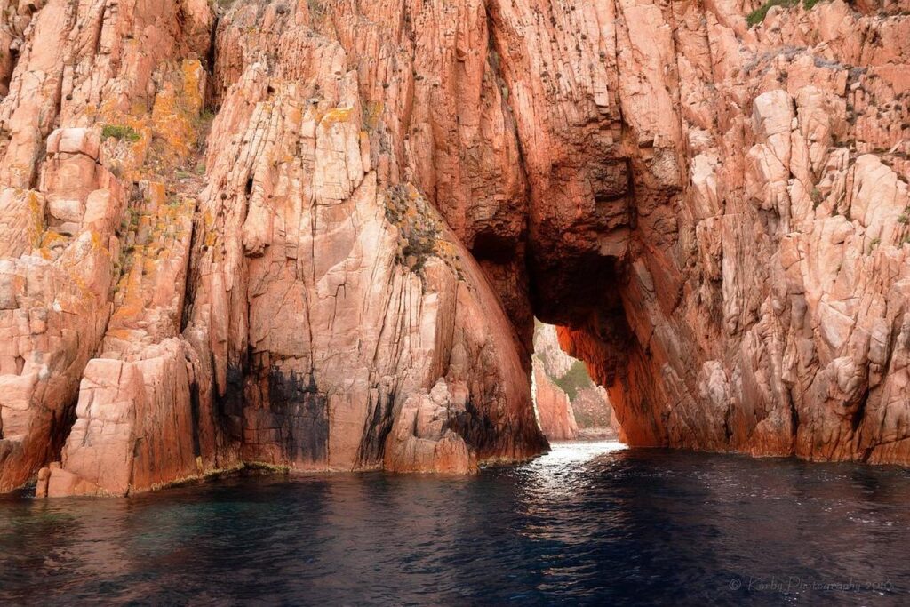
- Tightly packed contour lines: Indicators of cliffs or steep inclines where cave entrances often form.
Granted, some argue GPS and satellite imagery make paper maps outdated. However, topo maps show elevation changes and drainage relationships far more clearly—details that satellites can flatten or obscure.
Plotting Potential Entrances and Exits
Next, take a systematic approach:
- Circle sinkholes near drainage basins.
- Trace upstream where water vanishes.
- Mark steep valley walls as secondary targets.
- Plan primary and backup routes with elevation gain in mind.
This layered method increases efficiency and reduces wasted daylight (because bushwhacking blindly is nobody’s idea of fun—unless you’re in an adventure movie montage).
Water Is Your Guide
Most importantly, follow the water. Drainage patterns predict underground passage direction because caves form along natural flow paths. If surface streams converge, expect subsurface complexity below. Pro tip: prioritize lower elevation outlets after heavy rain; active flow often signals accessible passages. When in doubt, let gravity—and hydrology—lead the way.
On-Site Reconnaissance: Reading Ground-Level Clues
Serious cave discovery begins before you ever see an opening. It starts with observation.
The Vegetation Tells a Story
Plants are natural indicators of what lies below. Notice sudden shifts in vegetation height, density, or color. Lush, moisture-loving species clustered in an otherwise dry area may signal shallow soil over fractured bedrock. Sparse growth or stunted trees can indicate thin soil above voids. Roots follow water—and water often follows caves.
Recommendation:
- Compare plant patterns across short distances.
- Look for circular depressions with greener centers (possible sinkholes).
Geological Indicators
Not all rock welcomes caves. Limestone and dolomite—carbonate rocks formed from ancient marine deposits—are especially prone to dissolution. This chemical weathering process (called karstification) creates fissures, shafts, and chambers over time (U.S. Geological Survey).
Fractures, bedding planes, and fault lines act as pathways for water. The more fractured the rock, the higher the cave potential.
Pro tip: Fresh rockfall near a cliff base can expose hidden openings.
Airflow and Temperature Differentials
Caves “breathe” due to pressure and temperature differences between interior and exterior air (National Park Service). In summer, cool air flowing outward suggests a substantial passage inside. In winter, warmer drafts signal the same.
Place your hand near cracks. Feel for subtle airflow. It’s one of the most reliable signs.
Listening to the Landscape
Water is the master architect underground. A swallet is where a stream disappears beneath the surface; a resurgence is where it returns. If you hear running water with no visible channel, investigate carefully.
For deeper insight into hydrology, study understanding underground water flow patterns.
Effective terrain analysis for cavers blends sight, touch, and sound. Slow down. The ground is speaking.
Navigating the Interior: In-Cave Terrain Interpretation
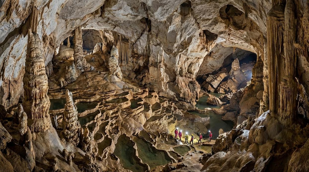
Caves don’t come with signposts. Instead, the walls, floors, and even the air act as your compass—if you know how to read them.
Passage Morphology as a Compass
First, study the shape of the passage. Tall, narrow canyon passages typically form from water cutting downward over time, suggesting a once-active vertical flow. In contrast, low, wide bedding planes often follow horizontal rock layers, hinting at lateral water movement along weaker strata. Some argue that formations are too irregular to reveal consistent patterns. While it’s true that collapses can distort original shapes, primary morphology usually leaves readable clues beneath the chaos. Think of it like reading a crumpled map—the lines are bent, not erased.
Reading the Floor
Next, look down. Sediment deposits often settle in slower-moving water, meaning finer silt points toward calmer downstream sections. Breakdown piles—collapsed ceiling rock—may block older routes, forcing water to reroute. Scalloping (small, spoon-shaped rock depressions) indicates flow direction; the tapered end points downstream (U.S. Geological Survey). This is core terrain analysis for cavers, not guesswork.
The Role of Airflow (Drafts)
Then there’s air. A lighter flame or even damp skin can detect subtle drafts. Moving air often signals larger passages or secondary entrances beyond. Skeptics say drafts are unreliable due to pressure shifts—but consistent airflow in stable weather is rarely random.
Using Formations for Orientation
Finally, consider speleothems. Stalactites grow downward with gravity, yet clusters may align along fracture zones that mirror passage trends. They’re supporting clues, not primary tools (think supporting actor, not lead role). Pro tip: pause often—observation beats speed underground.
Integrating Analysis into Confident Exploration
The first time I misread a cave map, I ended up circling the same limestone column for twenty minutes (humbling, to say the least). That experience taught me a simple truth: confidence underground is earned before you ever step inside.
Successful navigation starts with deliberate preparation. When you practice terrain analysis for cavers, you learn to interpret contour lines, drainage patterns, and subtle surface depressions as clues rather than random features. In plain terms, analysis means breaking complex environments into readable signals you can act on.
Some adventurers argue that too much planning dulls the thrill. They prefer instinct over study. I understand the appeal. But instinct without interpretation is just guesswork. Observation plus reflection—that’s strategy.
To build that strategy:
- Study maps in familiar terrain
- Compare surface markers to in-cave formations
- Pause regularly to reassess direction
Over time, these habits create a repeatable system. And systems, not luck, turn uncertainty into exploration you can trust.
While mastering advanced terrain analysis techniques is crucial for seasoned cavers aiming to navigate complex subterranean landscapes, beginners will find it equally important to first familiarize themselves with the foundational skills outlined in our article on cave trekking for beginners – for more details, check out our Cave Trekking for Beginners: Essential Skills to Get Started Safely.
Ready for Your Next Descent?
You came here to better understand Horizon headlines, strengthen your cave trekking fundamentals, and sharpen your survival and navigation skills. Now you have a clearer picture of how preparation, awareness, and terrain analysis for cavers work together to keep every expedition safe and rewarding.
Cave environments are unpredictable. One wrong turn, one misread surface, or one overlooked gear detail can quickly turn excitement into risk. That uncertainty is the pain point every caver faces — and the difference between a confident explorer and a vulnerable one comes down to knowledge and preparation.
The recommendation is simple: apply what you’ve learned before your next trip. Review your route. Double-check your gear. Practice navigation drills. Study terrain patterns. Preparation is not optional underground — it’s your lifeline.
If you’re serious about exploring smarter and safer, start putting these strategies into action today. Join the thousands of outdoor enthusiasts who rely on our trusted guidance to reduce risk and improve performance. Don’t head into your next cave unprepared — explore our latest resources now and take control of your next adventure.
 Trevana Dornhaven writes the kind of outdoor gear maintenance tips content that people actually send to each other. Not because it's flashy or controversial, but because it's the sort of thing where you read it and immediately think of three people who need to see it. Trevana has a talent for identifying the questions that a lot of people have but haven't quite figured out how to articulate yet — and then answering them properly.
They covers a lot of ground: Outdoor Gear Maintenance Tips, Cave Trekking Basics and Survival Skills, Horizon Headlines, and plenty of adjacent territory that doesn't always get treated with the same seriousness. The consistency across all of it is a certain kind of respect for the reader. Trevana doesn't assume people are stupid, and they doesn't assume they know everything either. They writes for someone who is genuinely trying to figure something out — because that's usually who's actually reading. That assumption shapes everything from how they structures an explanation to how much background they includes before getting to the point.
Beyond the practical stuff, there's something in Trevana's writing that reflects a real investment in the subject — not performed enthusiasm, but the kind of sustained interest that produces insight over time. They has been paying attention to outdoor gear maintenance tips long enough that they notices things a more casual observer would miss. That depth shows up in the work in ways that are hard to fake.
Trevana Dornhaven writes the kind of outdoor gear maintenance tips content that people actually send to each other. Not because it's flashy or controversial, but because it's the sort of thing where you read it and immediately think of three people who need to see it. Trevana has a talent for identifying the questions that a lot of people have but haven't quite figured out how to articulate yet — and then answering them properly.
They covers a lot of ground: Outdoor Gear Maintenance Tips, Cave Trekking Basics and Survival Skills, Horizon Headlines, and plenty of adjacent territory that doesn't always get treated with the same seriousness. The consistency across all of it is a certain kind of respect for the reader. Trevana doesn't assume people are stupid, and they doesn't assume they know everything either. They writes for someone who is genuinely trying to figure something out — because that's usually who's actually reading. That assumption shapes everything from how they structures an explanation to how much background they includes before getting to the point.
Beyond the practical stuff, there's something in Trevana's writing that reflects a real investment in the subject — not performed enthusiasm, but the kind of sustained interest that produces insight over time. They has been paying attention to outdoor gear maintenance tips long enough that they notices things a more casual observer would miss. That depth shows up in the work in ways that are hard to fake.