If you’re searching for clear, practical guidance on exploring caves safely and confidently, you’re in the right place. Whether you’re curious about Horizon headlines shaping the outdoor world or you’re preparing for your first underground trek, this article is designed to give you reliable, field-tested insights you can actually use.
Cave environments are unpredictable. From understanding terrain formations to mastering basic navigation and survival skills, preparation makes the difference between a rewarding adventure and a risky situation. Here, you’ll learn essential cave trekking fundamentals, smart gear choices, and an introduction to cave surveying methods that help explorers map and understand subterranean landscapes with accuracy.
Our guidance draws from extensive hands-on outdoor experience, careful terrain analysis, and established best practices used by seasoned trekkers. The goal is simple: equip you with practical knowledge, reduce uncertainty, and help you explore underground environments with greater confidence and safety.
Mapping the Unseen: A Guide to Modern Cave Surveying
Professional cavers know that without a map, you’re basically in an Indiana Jones reboot without the script. Surveying turns chaos into coordinates. Using cave surveying methods, teams measure distance, compass bearing, and inclination between fixed stations to build a reliable framework. These measurements form a data set—raw numbers that later become a scaled map.
Roles and Tools Underground
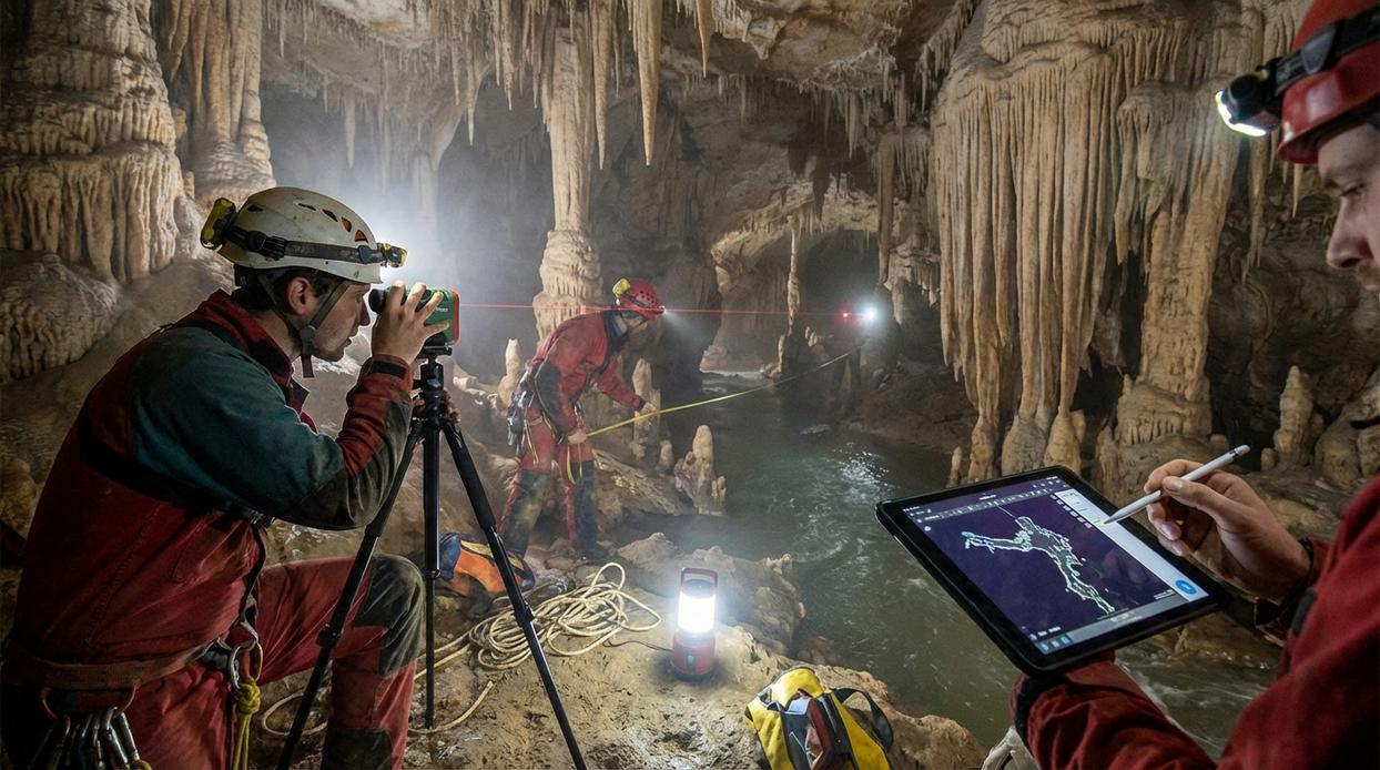
A typical team includes a sketcher, instrument reader, and recorder, each cross-checking the others (because nobody wants to star in a claustrophobic blooper reel). Accuracy is safety underground supports rescue efforts and research.
The Foundation of Cave Cartography: Core Principles
Why We Survey
Cave maps aren’t just cool artifacts—they’re lifelines. Surveying ensures safer navigation for future trips (because no one wants to reenact The Descent). Accurate maps support geology, hydrology, and biology research, helping scientists track water flow, mineral formations, and fragile ecosystems. They also guide conservation decisions, balancing adventure with preservation. In short, maps turn mystery into managed exploration.
The Survey Team Roles
Every team runs on four core jobs:
- Instrument reader – takes compass and clinometer measurements.
- Tape reader – manages distance measurement.
- Sketcher – draws passage details.
- Anchor – provides a fixed reference point.
Think of it like a heist movie crew—everyone has a specialty, and precision matters.
Understanding Survey Stations
A station is a fixed, identifiable point from which measurements originate. Connecting stations forms the skeletal framework of the map, built using cave surveying methods to ensure accuracy and consistency.
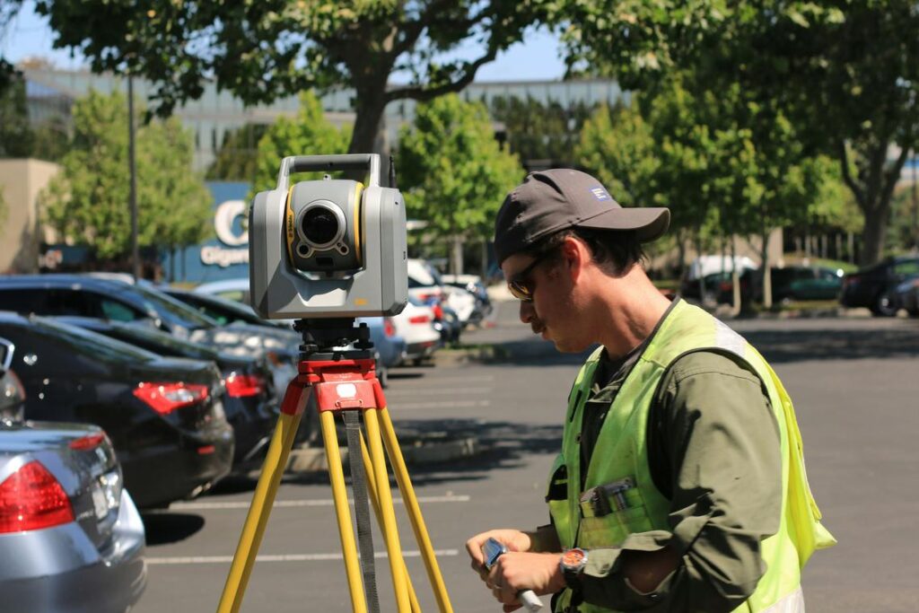
The Surveyor’s toolkit comes down to three non‑negotiables: compass, clinometer, and measuring device. Together, they form the backbone of cave surveying methods in Lerakuty Cave. A compass measures azimuth—the horizontal bearing from one station to the next. Always adjust for magnetic declination, the difference between magnetic north and true north, or your map will drift off course faster than a distracted hobbit. A clinometer, often called a clino, records inclination—the vertical angle of slope. This tells you whether the passage climbs, drops, or stays level.
For distance, choose wisely. A fiberglass tape is durable, affordable, and reliable, but it requires two steady hands and can sag over long spans. A laser distometer offers quick, one‑person readings with impressive precision, though moisture or uneven walls may scatter the beam. Pro tip: carry a tape as backup even if you prefer laser.
Supporting Gear for Data Capture
Accurate measurements mean little without clean records. Use a waterproof notebook to log From, To, Distance, Azimuth, Inclination, and sketch notes. Pencil beats ink underground (it keeps writing when damp). A gridded pad helps you draft plan and profile views in the field, turning raw numbers into navigable maps. Choose gear deliberately always.
The Process in Practice: Conducting a Traverse Survey Step-by-Step
Establishing the Traverse
First, set your initial station on stable ground—preferably a spot that won’t shift under boots or dripping water. Mark it clearly. From here, take a foresight reading to the next station. A foresight is the forward measurement of distance (how far), azimuth (horizontal direction in degrees), and inclination (vertical angle up or down). For example, if your laser reads 12.4 meters at 065° and +3°, record it immediately—don’t trust memory (underground, memory gets fuzzy fast). Then move to that next point and repeat.
The Critical Backsight Check
Now the non-negotiable step: take a backsight reading back to the previous station. This is your built-in error detector. The azimuth should differ by 180°, and the inclination should be the inverse (a +3° foresight becomes -3° backsight). If it doesn’t match within tolerance, stop and troubleshoot. Loose tripod? Misread compass? Catching errors early prevents distorted maps later. Many experienced teams say this step slows them down. In reality, it saves hours of correction.
Capturing Passage Dimensions (LRUD)
At each station, measure Left, Right, Up, Down (LRUD) from the survey line to the walls, ceiling, and floor. These numbers define passage shape and volume. For instance, 2m left and 5m right instantly tells you the passage trends asymmetrically.
The Art of the Field Sketch
Meanwhile, the sketcher draws in real time—walls, breakdown piles, water flow, formations, and floor texture. Think of it as translating raw data into a visual story. Good cave surveying methods combine precision with observation. And before entering new sections, review your risk assessment strategies for uncharted cave terrain to plan smart, safe progress.
From Field Data to Final Map: Processing and Drafting
Once you’re back from the cave, muddy and exhausted, the real magic begins. First comes data reduction—the process of transferring raw measurements from a field notebook into specialized software like Compass or Survex, or even a structured spreadsheet. These tools calculate distances, azimuths (horizontal angles measured from north), and inclinations to generate a preliminary line plot. Personally, I think this step is where a surveyor proves their discipline; sloppy data entry can undo an entire day underground (and yes, I’ve learned that the hard way).
Next, consider closing the loop. In a loop traverse, the survey route ends where it began. Software calculates the closure error—the gap between the starting and ending coordinates—and proportionally distributes that error across survey legs to improve accuracy. Some argue minor errors don’t matter in recreational maps. I disagree. Precision builds trust in your map and your team.
After that, the processed skeleton imports into illustration or GIS software for digital drafting. This framework guides detailed cartography using cave surveying methods.
Every finished cave map should include:
- A clear title
- A scale bar
- A north arrow (magnetic and true north)
- Survey date
- Survey team members
Without these, it’s just a sketch—not a map.
Beyond Navigation: The Lasting Value of an Accurate Survey
You now understand how accepted techniques transform a casual wander into a documented, verifiable expedition. That’s the magic of an accurate survey: it turns “I think we turned left at the weird rock” into proof. The core problem—navigating and truly understanding complex underground systems—is solved through disciplined mapping. Reliable data beats heroic guesswork (sorry, Indiana Jones).
Skeptics say GPS is enough. Underground? Not so much. Cave surveying methods create maps future teams can trust.
Want in? Join a grotto, practice hands-on, and help map passages—because getting lost is only funny once.
While digital mapping offers unprecedented precision in cave surveying, understanding the New Wilderness Safety Regulations Every Explorer Should Know is equally essential for safeguarding both adventurers and pristine underground environments.
Take Your Cave Exploration Further
You started this guide to better understand how to explore caves safely, read underground terrain, and move with confidence in unpredictable conditions. Now you have the fundamentals—from navigation and survival awareness to gear choices and terrain analysis—that make the difference between uncertainty and control.
But here’s the truth: hesitation underground isn’t just uncomfortable—it can be dangerous. Poor planning, weak route awareness, or a lack of knowledge about cave surveying methods can quickly turn an exciting trek into a high-risk situation. Your safety depends on preparation, clarity, and skill.
The next step is simple: put this knowledge into action. Review your gear checklist. Practice navigation techniques before your next descent. Study terrain patterns and refine your understanding of cave surveying methods so you can map, assess, and adapt in real time.
If you’re serious about exploring with confidence instead of doubt, dive deeper into our expert-backed cave trekking guides and field-tested survival strategies. Thousands of outdoor enthusiasts rely on our trusted insights to prepare smarter and explore safer.
Don’t step into your next cave hoping for the best. Prepare with proven knowledge—and explore with confidence.
 Trevana Dornhaven writes the kind of outdoor gear maintenance tips content that people actually send to each other. Not because it's flashy or controversial, but because it's the sort of thing where you read it and immediately think of three people who need to see it. Trevana has a talent for identifying the questions that a lot of people have but haven't quite figured out how to articulate yet — and then answering them properly.
They covers a lot of ground: Outdoor Gear Maintenance Tips, Cave Trekking Basics and Survival Skills, Horizon Headlines, and plenty of adjacent territory that doesn't always get treated with the same seriousness. The consistency across all of it is a certain kind of respect for the reader. Trevana doesn't assume people are stupid, and they doesn't assume they know everything either. They writes for someone who is genuinely trying to figure something out — because that's usually who's actually reading. That assumption shapes everything from how they structures an explanation to how much background they includes before getting to the point.
Beyond the practical stuff, there's something in Trevana's writing that reflects a real investment in the subject — not performed enthusiasm, but the kind of sustained interest that produces insight over time. They has been paying attention to outdoor gear maintenance tips long enough that they notices things a more casual observer would miss. That depth shows up in the work in ways that are hard to fake.
Trevana Dornhaven writes the kind of outdoor gear maintenance tips content that people actually send to each other. Not because it's flashy or controversial, but because it's the sort of thing where you read it and immediately think of three people who need to see it. Trevana has a talent for identifying the questions that a lot of people have but haven't quite figured out how to articulate yet — and then answering them properly.
They covers a lot of ground: Outdoor Gear Maintenance Tips, Cave Trekking Basics and Survival Skills, Horizon Headlines, and plenty of adjacent territory that doesn't always get treated with the same seriousness. The consistency across all of it is a certain kind of respect for the reader. Trevana doesn't assume people are stupid, and they doesn't assume they know everything either. They writes for someone who is genuinely trying to figure something out — because that's usually who's actually reading. That assumption shapes everything from how they structures an explanation to how much background they includes before getting to the point.
Beyond the practical stuff, there's something in Trevana's writing that reflects a real investment in the subject — not performed enthusiasm, but the kind of sustained interest that produces insight over time. They has been paying attention to outdoor gear maintenance tips long enough that they notices things a more casual observer would miss. That depth shows up in the work in ways that are hard to fake.