
Cave trekking isn’t just about stepping into the dark—it’s about understanding the hidden systems that shape every tunnel, drop, and chamber you’ll encounter. If you’re searching for clear, practical guidance on how to read cave terrain, move safely underground, and prepare for the unexpected, this guide delivers exactly that. We break down essential cave trekking basics, from navigation techniques and survival skills to gear choices that hold up in extreme subterranean conditions.
A major focus is learning how to identify and interpret underground water flow patterns, which influence passage stability, flooding risks, and route accessibility. Recognizing these patterns can mean the difference between a safe expedition and a dangerous miscalculation.
This article draws on field-tested outdoor practices, established caving safety principles, and terrain analysis methods used by experienced trekkers. Whether you’re preparing for your first cave entry or refining advanced exploration skills, you’ll gain actionable insights to move smarter, safer, and more confidently underground.
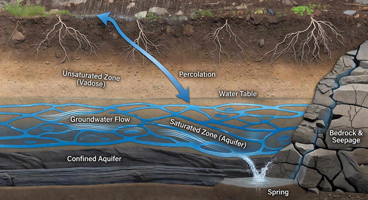
Groundwater feels mysterious, yet it follows clear rules. Hydrology—the study of water movement—shows that gravity and pressure differences push water through porous rock layers called aquifers. Think of an aquifer like a soaked sponge beneath your boots (yes, even in deserts).
To read underground water flow patterns in the field, start with practical steps:
- Observe surface clues such as lush vegetation or damp soil.
- Note rock type; sandstone stores water, granite usually does not.
- Track slope direction, because water moves downhill before rising under pressure.
However, remember seasonal rainfall can reverse expectations. Therefore, test before digging wells.
The Anatomy of an Aquifer: Earth’s Hidden Reservoirs
To gain a deeper insight into how underground water flow patterns influence the landscape above, it’s essential to equip yourself with tools like a compass and altimeter, as discussed in our article on Using Compass and Altimeter Tools Underground.
An aquifer is a natural underground layer of rock or sediment that holds and transmits water. Think of it as a buried reservoir made of permeable rock, gravel, sand, or silt. According to the U.S. Geological Survey (USGS), aquifers supply about 37% of the public water supply in the United States, making them critical to daily life.
Picture a sponge. The aquifer itself is the sponge. Porosity is the tiny spaces inside it that store water. Permeability is how easily water can flow through those spaces. High-porosity sand with high permeability moves water efficiently; dense clay may hold water but barely lets it pass.
Not all underground layers cooperate. An aquitard (or aquiclude) is impermeable material—like clay—that blocks water flow. This trapping effect can build pressure, creating artesian wells that flow without pumping (yes, nature sometimes does the plumbing).
The water table marks the upper boundary where soil and rock are fully saturated. Its depth shifts with rainfall, drought, and seasonal demand.
Why it matters:
- Aquifer type controls recharge speed.
- Filtration through rock affects purity.
- Seasonal shifts influence underground water flow patterns.
Research shows overpumping can lower water tables dramatically, as seen in California’s Central Valley (USGS). Understanding aquifers isn’t trivia—it’s survival science.
Gravity and geology control every drop of groundwater beneath your boots. Despite high-tech sensors and satellite maps, the real engines are stubbornly simple: gravity and pressure. Gravity pulls water downhill; pressure pushes it toward open spaces. Together, they create natural motion in places that look perfectly still.
The key concept is the hydraulic gradient. That’s the energy slope between two points, usually measured as differences in elevation or pressure. Water moves from higher energy to lower energy, just as a ball rolls downhill. Some argue groundwater drifts randomly through rock, but that’s misleading. Flow follows gradients with remarkable consistency.
Then there’s hydraulic conductivity—a material’s ability to transmit water. Gravel and fractured limestone have high conductivity, so water can surge through them. Clay, by contrast, resists flow so strongly it can slow movement to inches per year. Think of it as the difference between sprinting through a hallway and squeezing through a packed subway car.
Darcy’s Law ties these ideas together. In plain terms, groundwater moves faster when the gradient is steeper and the material more permeable. No equations needed—just picture a steeper hill and a wider pipe.
This explains why wells in valleys are often more productive than those on ridges. Water naturally converges at lower elevations. It also explains how underground water flow patterns can carry water miles from a recharge zone to a distant spring. Mapping those paths relies on tools and methods for accurate cave mapping. Geology ultimately sets the real limits.
From Seepage to Springs: Common Groundwater Movement Patterns
Flow beneath our feet follows three distinct scripts, yet most guides oversimplify them. Let’s look closer.
Unconfined Aquifers
In unconfined systems, permeable soil or rock sits above the saturated zone, meaning the water table—(the upper surface of groundwater)—rises and falls with rainfall. After heavy storms, streams swell because they’re directly fed by this shifting reserve. During drought, wetlands shrink. It’s responsive, visible, and measurable (nature’s own barometer). Competitors rarely discuss how subtle slope changes can redirect underground water flow patterns, altering spring output within weeks.
Confined Aquifers
Here, water-bearing layers are trapped between impermeable strata, building pressure. Drill into one, and the hydraulic head—(stored energy from compression)—can push water upward without pumps. That’s an artesian well. While textbooks praise their reliability, few note pressure variability across fault lines, which can create uneven flow rates over short distances.
Karst Systems
In limestone terrain, water doesn’t seep—it races. Slightly acidic rain dissolves rock, carving conduits and tunnels. A storm miles away can flood a cave in minutes. Unlike porous aquifers, flow paths here are turbulent, fast, and unpredictable—more subway tunnel than sponge. Few resources emphasize dye-tracing studies, which reveal just how swiftly contaminants can travel.
| Aquifer Type | Flow Speed | Key Trait |
|---|---|---|
| Unconfined | Slow–Moderate |
Rain-responsive |
| Confined | Moderate | Pressurized |
| Karst | Rapid | Channelized |
Understanding these distinctions isn’t academic; it’s survival. Predict the water, and you predict the landscape’s next move. Stay alert.
Reading the Terrain: Practical Clues to Subsurface Water
Finding hidden groundwater isn’t guesswork; it’s observation. Start with:
- Topographical Analysis: Contour lines reveal slope. Groundwater usually moves downhill, mirroring surface gradients and broader underground water flow patterns. V-shaped contours pointing uphill mark valleys—prime recharge pathways.
- Vegetation Signals: Water-loving plants called phreatophytes tap shallow water tables. Lush willows or cottonwoods in dry zones often mean water below (nature’s neon sign).
- Seeps and Springs: A spring is a direct aquifer window. Note location, flow rate, and temperature; cold, steady discharge suggests deep, confined sources.
Map first, dig second. Trust observable clues over hope.
Understanding subsurface water isn’t just academic—it’s survival. Many hikers feel the frustration of scanning a dry valley, wondering where the map promised a stream. The truth is that predicting the unseen feels impossible until you grasp gravity, pressure, and geology. When you learn to read topography, vegetation, and rock type, clues start aligning. Suddenly, underground water flow patterns make sense, guiding you toward springs instead of guesswork. That’s the shift. No more wandering ridge after ridge.
• Spot low saddles where moisture gathers.
• Notice thirsty plants thriving where others fail.
The spring you find won’t feel lucky—it’ll feel earned.
Keep Exploring With Confidence Beneath the Surface
You set out to better understand Horizon headlines, cave trekking fundamentals, and how to move safely through complex underground terrain. Now you have a clearer grasp of navigation techniques, survival priorities, gear selection, and even how underground water flow patterns can shape the caves you explore.
Cave environments are unpredictable. Low visibility, shifting terrain, and hidden hazards can turn a simple trek into a dangerous situation if you’re unprepared. That uncertainty is the biggest pain point for most explorers—the fear of making one wrong move underground.
The good news? With the right knowledge and preparation, you dramatically reduce that risk. When you understand terrain analysis, read water movement correctly, and carry dependable gear, you explore with control instead of guesswork.
Now it’s time to put this into action. Review your current gear setup, practice your navigation skills before your next trek, and deepen your understanding of cave dynamics so you’re never caught off guard.
If you’re serious about safer, smarter cave exploration, rely on trusted, field-tested guidance from one of the most respected sources in cave trekking insights. Get the practical strategies you need, sharpen your skills, and prepare for your next descent with confidence—start refining your approach today.